


Ordnance Datum
Description
This section is from the book "Cassell's Cyclopaedia Of Mechanics", by Paul N. Hasluck. Also available from Amazon: Cassell's Cyclopaedia Of Mechanics.
Ordnance Datum
The Ordnance datum is an imaginary horizontal plane extending over the whole country at the same height as the average mean level of the sea at Liverpool. This datum was fixed by the surveyors of the Ordnance Department, and the levels of districts are marked on the Ordnance maps as being 80 many feet above the Ordnance datum, that is, above the average sea-level at Liverpool. The accompanying illustration shows a small portion of the 1/500 Ordnance map. At the corner of the house a bench-mark has been cut (these are usually about 1ft. 6 in. above the surface of the ground), and the figures indicate that the point is at a height of 89.55ft. above Ordnance datum. The figure in the roadway indicates that the road at that point is about 877 ft. above the datum, the second place of decimals not being given.
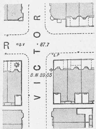
Ordnance Datum.
Continue to:


My Books

